Skills/Training: Navigation
It doesn’t matter how fast you run, bike or paddle if you go in the wrong direction… If you can’t find your way from point A to point B, you won’t be making it very far in an adventure race. As noted previously, many adventure races, especially sprint races and one-day events accessible to beginners, are designed with less experienced navigators in mind, but you will still want and need a certain level of comfort with maps.
More so than any other skill set, you’ll need to practice navigation. The single best way to train for navigation is by participating in weekend orienteering meets or finding permanent orienteering courses in your local parks. See if you have a local club, and check out their schedule. Local O-meets are great ways to practice reading maps and navigating from CP to CP like you would in an adventure race. Most weekend O-meets offer a range of events, from short beginner courses to long-advanced ones. Many participants take part in multiple courses on a given weekend. Working your way up from beginner to more advanced courses is terrific training for adventure racing.
Keep in mind, while orienteering has codified, and very detailed, standard rules for maps that must be used in official meets, that Adventure Racing does not. Example: on one map, a patch of the color white or a black dotted line can mean something different from one map to another depending on who made it. Many Adventure Races are held in places/areas that may not be as frequented and have ready-to-go super detailed maps. As such many AR Race Directors must rely on topographic maps from USGS or similar mapmaking organizations for most if not all of their events. It’s not uncommon for an RD to use an orienteering map for a specific more widely-known section of the course, but most of the time, especially in longer events, you’ll need to be well versed in reading a standard topographic map.
In short, being able to work with all sorts of different maps is important: O-maps, topo maps, park-specific maps, etc. And the basics of map-reading and navigation apply to all AR navigation: reading/understanding a legend, understanding scale, how to orient the map, learning what all the different colors and lines mean, and staying found on it are all important regardless of what sort of map you are using.
Beyond organized events like beginner adventure races or orienteering events, try printing your own maps for a local park or state forest. Play around with park-specific maps, and use a free online mapping program like Caltopo or ESRI or USGS to print your own topographic map. Head out into the woods and use the map to navigate. You might even mark your map ahead of time with virtual CPs and try to find them (trail junctions, off-trail hilltops, reentrants, etc...).

Permanent O-course CP
Permanent Orienteering Courses are a great way to practice navigation on your own time, but with the level of detail you get in an orienteering meet. Many state, regional and local parks have installed permanent O-courses, meaning they have installed posts out around their park with colored (white/orange) signs on them with designated numbers. You can usually download these maps from the park website and go out and try the course whenever you want.
Learn to plan a route, go do it, then try a different route on a different day. Start to understand the importance of planning an efficient route or marking where you may need to “make a game-time decision” on which direction to go because you need to see the terrain before you can decide. Is it faster to go in a straight line from one CP to another? Not always if doing so involves a ton of elevation and difficult landscape like water, swamp, heavy vegetation, rocky cliffsides, etc. Sometimes going “the long way around” from a distance perspective can be much quicker if it affords you the opportunity to use a well established trail, gravel road, or an open field.
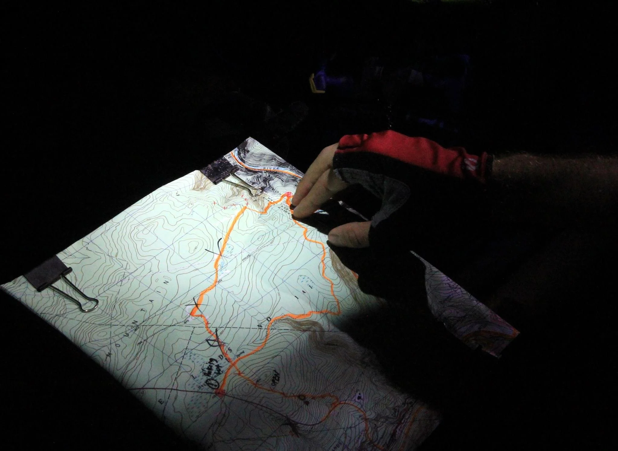
When you are ready, head off into a local park at night with your map and practice navigating in the dark. Be sure to play it safe and make sure someone knows what you're up to, or go in a group. Bring a friend. Go somewhere with cell reception. No need to go crazy here, but practicing a bit in the dark will be really useful when it’s time to tackle your first overnight AR. Also make sure the park or area you are in is open to the public at night.

Work out the navigational roles for your team: in terms of who is making navigational decisions, who will have the maps, what will the team do when you “get close” to a checkpoint? Is there a backup navigator or co-navigator to help with “game-time decisions?” That last thing you want to do during an adventure race is waste large amounts of time debating on where you want to go; oftentimes beginners can get paralyzed worrying about making the wrong decisions. The reality is that ALL adventure races make navigational mistakes during every race, even the best teams in the world. What separates better navigators/racers apart is the ability to catch mistakes/bobbles quicker. Make decisions quickly, but learn how to quickly figure out if you are on the right path, are you where you think you are going, something that tells you that you are in the right or wrong place. Example: “if we walk in the correct direction for X amount of time then we should come across a railroad track.” Involve the whole team with this information so they aren’t just blindly following, the navigator may be the person with the maps in their hands, but that doesn’t mean the whole team can’t work together to navigate the course.
Finally, read a book, or watch some videos on youtube. There is an academic side to navigating, and it’s worth studying in addition to the field work!